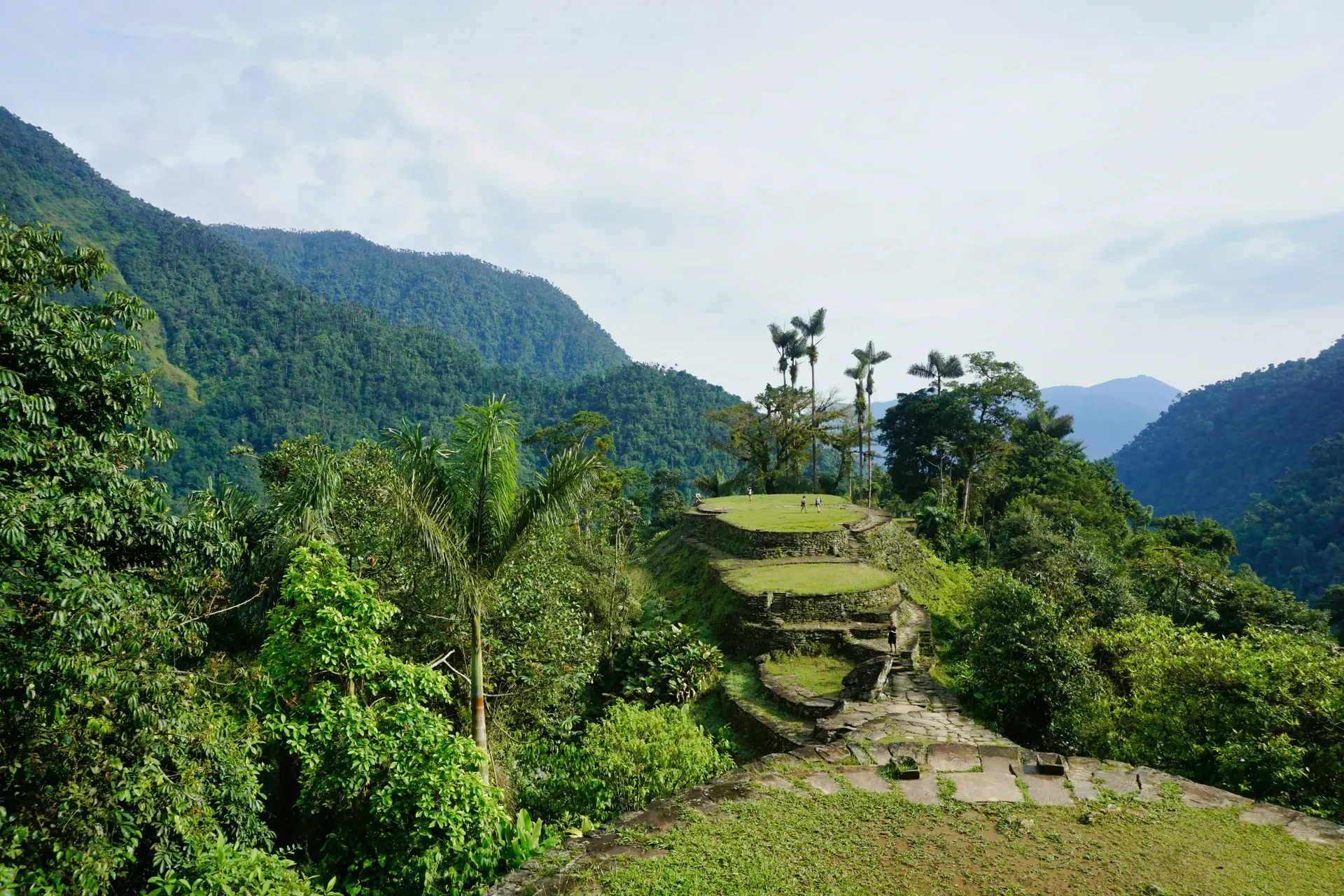
Built around 800 AD, Ciudad Perdida consists of 169 stone terraces carved into the Sierra Nevada de Santa Marta mountains of Colombia. This ancient Tairona capital predates Machu Picchu by 650 years and requires a grueling multi-day jungle trek to reach.
Ciudad Perdida, known locally as Teyuna, occupies 86 acres of rugged mountain slopes in Colombia's Sierra Nevada de Santa Marta. The site sits at an elevation of 3,000 feet. Dense tropical rainforests, towering wax palms, and giant ferns surround the ruins along the Buritaca River. Extreme heat, high humidity, and torrential downpours define the local ecosystem. Visitors access the area exclusively on foot through an authorized 4-day or 5-day guided trek. The route demands crossing the Buritaca River and navigating steep clay paths. These trails turn into hazardous mudslides during the March to November rainy season.
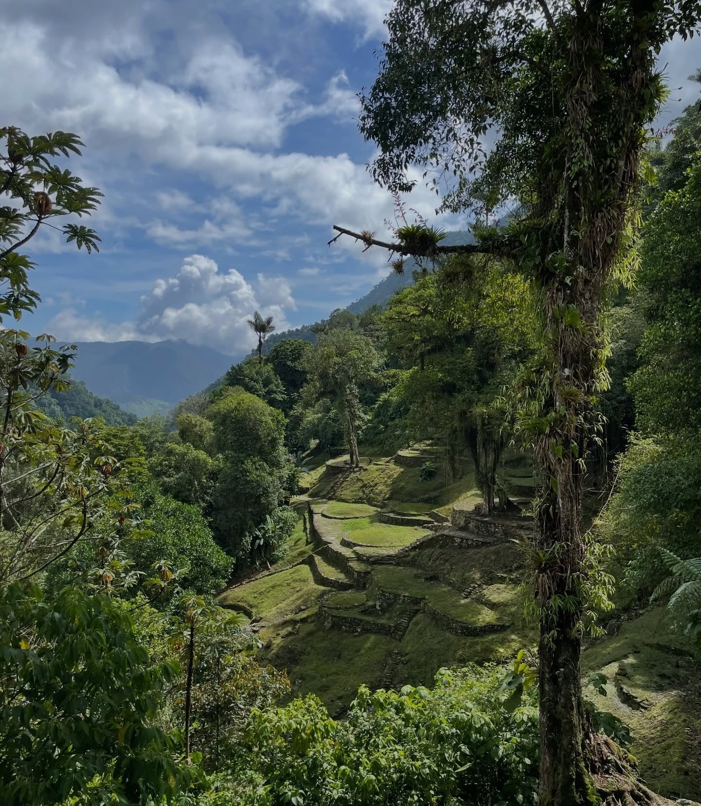
The Tairona civilization built this political and manufacturing center around 800 AD. The city predates Peru's Machu Picchu by 650 years. Reaching the main terraces requires climbing 1,200 narrow, moss-covered stone steps carved directly into the mountainside. At the summit, hikers find 169 stone terraces, a network of tiled roads, and several circular plazas. Sweeping, misty views of the surrounding Sierra Nevada peaks open up from the edge of the massive La Capilla platforms.
The site remains an active sacred ground for descendant indigenous communities. October brings a complete closure of the trail and ruins to allow the Arhuaco, Kogui, Kankuamo, and Wiwa people to perform private cleansing ceremonies. Independent trekking is strictly prohibited. Travelers must book an all-inclusive tour starting at 1,860,000 COP, which covers permits, jungle camp accommodation, and community contributions.
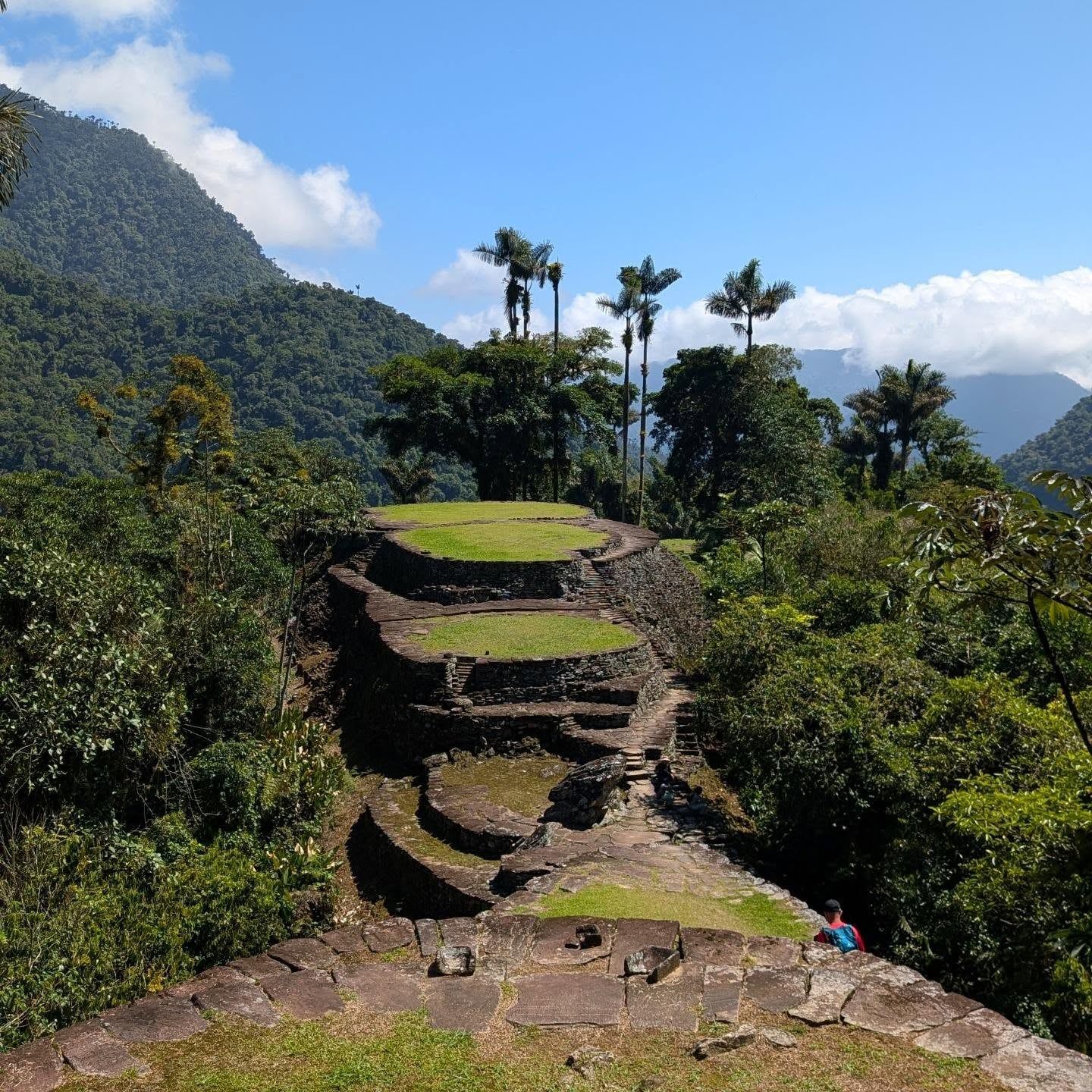
The Tairona people established Teyuna around 800 AD. Some residential sectors date back even earlier to the Neguanje period around 650 AD. The city grew into a major regional hub housing between 2,000 and 8,000 residents. Engineers carved stone terraces into the steep hillsides to support wooden and thatched-roof structures. A complex network of stone-paved paths connected the city to other coastal and mountain settlements. The inhabitants manufactured pottery, crafted gold ornaments, and managed agricultural terraces that sustained the large population.
Spanish colonizers arrived on the Colombian coast in the late 16th century. The resulting conflicts and introduced diseases decimated the local population. The Tairona abandoned Teyuna between 1580 and 1650, retreating deeper into the Sierra Nevada mountains to survive. The jungle rapidly consumed the city. Thick vines, roots, and dense foliage buried the stone terraces and plazas. The site remained completely hidden from the outside world for nearly four centuries. Surviving indigenous groups knew its location but kept it a closely guarded secret from outsiders.
A group of local treasure looters called Los Sepúlvedas stumbled upon the ruins in 1972 while hunting for birds. They found stone steps leading up the mountain and began extracting gold figures and ceramic urns. These artifacts soon flooded the local black market, catching the attention of authorities. The Colombian government dispatched soldiers and archaeologists to the site in 1976. They secured the area, halted the looting, and began the slow process of clearing the overgrowth to restore the stone foundations.
The site gained international protection in 1986 when UNESCO designated it a Biosphere Reserve and World Heritage Site. The Colombian military established a permanent high mountain battalion along the trekking route to ensure security. Today, armed soldiers patrol the trail and interact with passing hikers. The government strictly regulates access to prevent overtourism and environmental degradation. Visitors can only enter alongside licensed guides from authorized agencies like Wiwa Tours or Magic Tour Colombia.
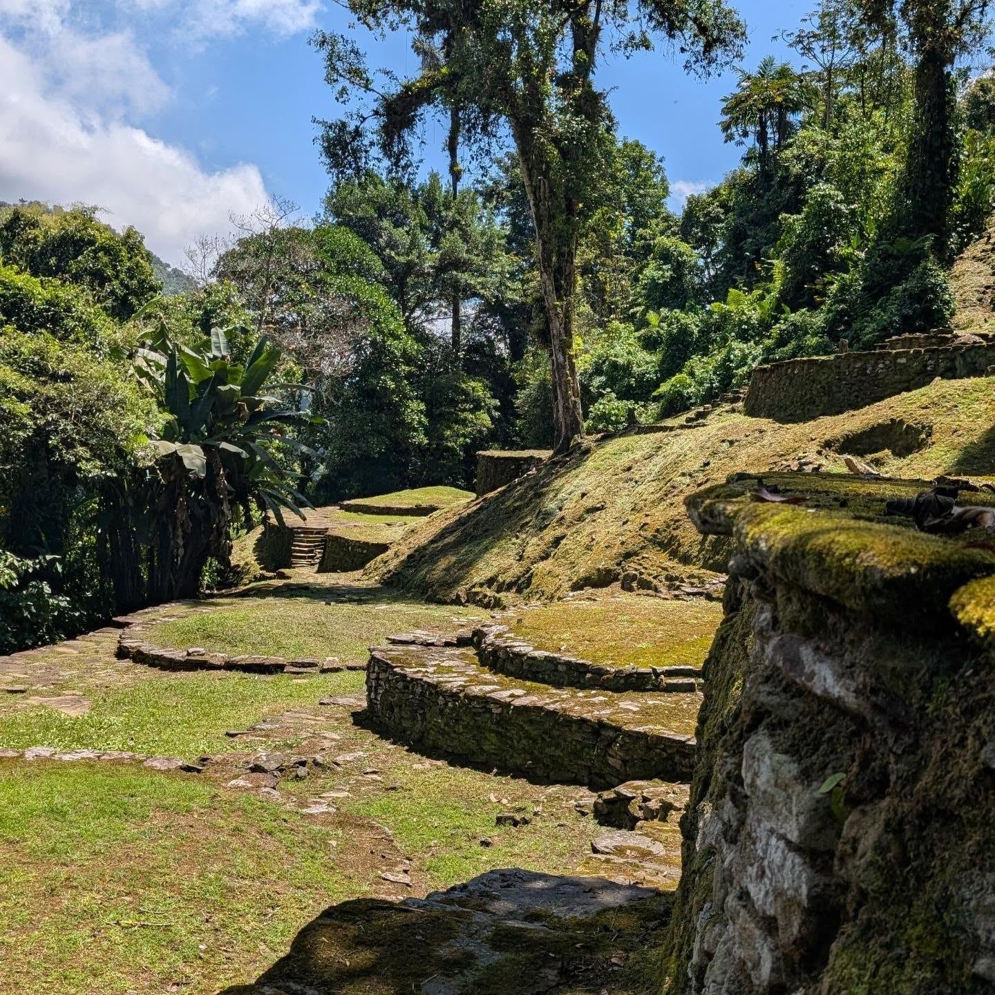
The archaeological complex spans 86 acres across the steep ridges of the Sierra Nevada. Builders constructed 169 circular stone terraces directly into the mountainside. These platforms range from 15 to 40 feet in diameter and originally supported large wooden houses with thatched roofs. A sophisticated drainage system channels the region's heavy rainfall away from the foundations, preventing erosion on the steep slopes. Retaining walls built from massive stone blocks hold the earth in place.
A central axis of stone-paved paths connects the various residential and ceremonial sectors. The most prominent feature is the grand staircase. Visitors must climb 1,200 narrow, uneven stone steps to reach the main plazas. These stairs become highly slick when coated in rain and moss. The upper section, known as La Capilla, contains the largest terraces. This area formed the political and spiritual core of the city.
The surrounding environment dictates the site's physical reality. The Buritaca River flows at the base of the mountain, providing fresh water and natural rock pools. Dense foliage, towering wax palms, and giant ferns encroach on the cleared stone areas. The clay-heavy soil turns into deep, slippery mud during the rainy season from March to November. Hikers rely on trekking poles to navigate the steep, unstable terrain leading up to the ruins.
Teyuna functions as the sacred ancestral heartland for the Arhuaco, Kogui, Kankuamo, and Wiwa indigenous communities. These groups consider themselves the direct descendants of the Tairona and the "Elder Brothers" of humanity. They believe the Sierra Nevada de Santa Marta is the beating heart of the world. The stone terraces are not just ruins, but active spiritual centers where traditional leaders, known as Mamos, conduct rituals to maintain cosmic balance.
The daily lives of the indigenous residents remain deeply tied to ancient customs. Men practice the ritual of the "paporo," using hollowed-out gourds and crushed seashells mixed with coca leaves. This practice represents the union of male and female energies and acts as a tool for meditation and recording thoughts. Women are traditionally permitted to pick coca leaves only during their menstrual cycles, and consuming the leaves is strictly prohibited for them.
Visitors encounter these living traditions throughout the trek. The trail passes through the Kogui village of Mutanyi, where families live in circular thatched-roof huts and wear traditional white clothing. The annual October closure of the entire archaeological park demonstrates the priority given to indigenous rights. During this month, the communities perform private cleansing ceremonies to heal the land from the energetic impact of foreign visitors.
Founded around 800 AD, Ciudad Perdida predates the famous Incan citadel in Peru by approximately 650 years.
Reaching the main terraces requires climbing a grueling, moss-covered staircase carved directly into the steep mountainside.
A group of local treasure looters stumbled upon the jungle-covered ruins in 1972 while hunting for birds.
The entire archaeological park shuts down for one month annually so indigenous communities can perform private cleansing ceremonies.
Authorities strictly prohibit drones on the trail and at the site to protect the privacy of local indigenous residents.
The Colombian military maintains a permanent high mountain battalion along the trekking route to ensure visitor safety.
Indigenous women are traditionally permitted to pick coca leaves only during their menstrual cycles, and consuming them is strictly forbidden for women.
In 2026, the standardized price for the shared 4-day and 5-day treks ranges between 1,860,000 COP and 2,150,000 COP. This all-inclusive rate covers round-trip transport from Santa Marta, professional guides, jungle camp accommodation, meals, and park entry fees.
No, independent trekking to Ciudad Perdida is strictly prohibited by the government and indigenous authorities. All visitors must book an organized tour through an authorized agency to secure permits. These mandatory tours help fund local indigenous communities and ensure environmental preservation.
To access the main archaeological site, visitors must climb a flight of 1,200 steep, narrow stone steps. The Tairona people carved these stairs into the mountainside over a thousand years ago. The path becomes highly slippery when wet.
A group of local treasure looters known as Los Sepúlvedas rediscovered the city in 1972 while hunting. Ceramic artifacts soon began appearing on the local black market. The Colombian government sent soldiers and archaeologists to officially protect the site in 1976.
The Tairona founded Ciudad Perdida around 800 AD, with some residential areas dating back as early as 650 AD. This timeline makes the ancient Colombian city approximately 650 years older than Peru's famous Machu Picchu.
Accommodation consists of rustic, open-air jungle camps run by local families and indigenous communities. Hikers sleep in long rows of bunk beds or hammocks. Each bed includes a protective mosquito net to keep out jungle insects.
Yes, potable water is provided at the cabins and camps. The water is typically sourced from the river and chemically treated in large containers for safe refilling. Hikers do not need to bring water purifying tablets.
The Colombian military maintains active posts and a high mountain battalion along the trail to ensure safety. Visitors will see armed soldiers in uniform stationed at various points. These troops guarantee the route remains secure for tourists and locals.
Tours operate most of the year, but the trail and archaeological site close completely during the month of October. This annual closure allows the indigenous communities to perform sacred cleansing ceremonies without tourist presence.
The dry season from December through early March offers the best conditions for the trek. During this period, the Buritaca River is lower and easier to cross. Hikers also avoid the worst of the torrential jungle downpours that turn the clay trails into deep mud.
Browse verified tours with free cancellation and instant confirmation.
Find Tours